Android and Google Maps. This tutorial describes the usage of Google Maps in your Android application. In this article, I am sharing how to used a google map in android and how to show a marker on current location and source
And in these article, I am sharing how to show root in google map and show these root alternate root and calculate the distance start to end point
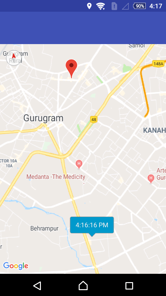
Used a start trip run on google map
Step 1: First one to Start Android Studio
Step 2 : Seconds step to Create a New Project Project ClickOn ==> File ==> NEW ==> New Project
And select the google map activity in the android studio.
Step 3: Gradle Scripts Open Project base and add these
uildscript {
    repositories {
        jcenter()
    }
    dependencies {
        classpath 'com.android.tools.build:gradle:2.3.3'
       classpath 'com.google.gms:google-services:3.1.0'
   }
}
allprojects {
    repositories {
        mavenLocal()
        mavenCentral()
        maven {                                  // <-- Add this
           url 'https://maven.google.com/'
           name 'Google'
       }
        jcenter()
        maven {
            url "https://jitpack.io"
       }
    }
}

task clean(type: Delete) {
    delete rootProject.buildDir
}
And App Base build.gradle and add these
First, one to add google service in your gradle.
dependencies {
    compile fileTree(include: ['*.jar'], dir: 'libs')
    androidTestCompile('com.android.support.test.espresso:espresso-core:2.2.2', {
        exclude group: 'com.android.support', module: 'support-annotations'
    })
    compile 'com.android.support:appcompat-v7:27.0.2'
    compile 'com.android.support.constraint:constraint-layout:1.0.2'
    compile 'com.android.support:design:27.0.2'
    compile 'com.android.support:support-v4:27.0.2'
    compile 'com.android.volley:volley:1.0.0'
    compile 'com.google.firebase:firebase-messaging:11.0.4'
    compile 'com.google.android.gms:play-services-base:11.0.4’
    compile 'com.google.android.gms:play-services-maps:11.0.4'
    compile 'com.google.maps.android:android-maps-utils:0.4.3'
    compile 'com.google.android.gms:play-services-location:11.0.4'
    compile 'org.jsoup:jsoup:1.11.2'
    testCompile 'junit:junit:4.12'
}
apply plugin: 'com.google.gms.google-services'
Step 4: Open your XML file add these
<?xml version="1.0" encoding="utf-8"?>
<LinearLayout xmlns:android="http://schemas.android.com/apk/res/android"
    xmlns:app="http://schemas.android.com/apk/res-auto"
    xmlns:tools="http://schemas.android.com/tools"
    android:layout_width="match_parent"
    android:layout_height="match_parent"
    android:orientation="vertical"
    tools:context="com.codeplayon.StartTrip">

    <TextView
        android:id="@+id/RootText"
        android:layout_width="match_parent"
        android:layout_height="wrap_content"
        android:padding="2dp"
        android:background="@color/colorPrimary"
        android:textColor="@color/text"/>
    <TextView
        android:id="@+id/RootText1"
        android:layout_width="match_parent"
        android:layout_height="wrap_content"
        android:padding="2dp"
        android:background="@color/colorPrimary"
        android:textColor="@color/text"/>

    <TextView
        android:id="@+id/RootText2"
        android:layout_width="match_parent"
        android:layout_height="wrap_content"
        android:padding="2dp"
        android:background="@color/colorPrimary"
        android:textColor="@color/text"/>
    <fragment
        android:id="@+id/map"
        class="com.google.android.gms.maps.SupportMapFragment"
        android:layout_width="match_parent"
        android:layout_height="match_parent" />

</LinearLayout>
Step 5: Open your java file and add these code
public class StartTrip extends FragmentActivity implements OnMapReadyCallback, GoogleApiClient.ConnectionCallbacks, GoogleApiClient.OnConnectionFailedListener, LocationListener, RoutingListener {
    private GoogleMap mMap;
    double Latitude;
    double Longitude;
    protected LatLng start;
    protected LatLng end;
    TextView RouteText,RouteText1,RouteText2;
    //    double Latitude1;
//    double Longitude1;
   Location mCurrentLocation;
    String mLastUpdateTime;
    private static final String LOG_TAG = "MyActivity";

    LocationRequest mLocationRequest;
    GoogleApiClient mGoogleApiClient;
    String Name, Address;
    AutoCompleteTextView destination;
    AutoCompleteTextView starting;
    private List<Polyline> polylines;
    private static final int[] COLORS = new int[]{R.color.driving,R.color.colorPrimary,R.color.colorAccent,R.color.secondryText,R.color.primary_dark_material_light};

    private static final long INTERVAL = 1000 * 60 * 1; //1 minute
   private static final long FASTEST_INTERVAL = 1000 * 60 * 1; // 1 minute
   private static final String TAG = "LocationTracker";
    @Override
    protected void onCreate(Bundle savedInstanceState) {
        super.onCreate(savedInstanceState);
        logEvent("onCreate");
        //show error dialog if GoolglePlayServices not available
       if (!isGooglePlayServicesAvailable()) {
            finish();
        }
        // Create Location Request
       createLocationRequest();
        polylines = new ArrayList<>();
        // Initialize GoogleApiClient
       mGoogleApiClient = new GoogleApiClient.Builder(this)
                .addApi(LocationServices.API)
                .addConnectionCallbacks(this)
                .addOnConnectionFailedListener(this)
                .build();
        setContentView(R.layout.activity_start_trip);
        SupportMapFragment mapFragment = (SupportMapFragment) getSupportFragmentManager()
                .findFragmentById(R.id.map);
        mapFragment.getMapAsync(this);
        Latitude = getIntent().getDoubleExtra("lat", Latitude);
        Longitude = getIntent().getDoubleExtra("log", Longitude);
        Address = getIntent().getStringExtra("address");
        end=new LatLng(Latitude,Longitude);

        Name = getIntent().getStringExtra("name");
        RouteText=(TextView)findViewById(R.id.RootText);
        RouteText1=(TextView)findViewById(R.id.RootText1);
        RouteText2=(TextView)findViewById(R.id.RootText2);


//        String lat=bundle.getString("lat");
//        String longs=bundle.getString("long");
//        Latitude1= Double.parseDouble(lat);
//        Longitude1=Double.parseDouble(longs);
   }

    private boolean isGooglePlayServicesAvailable() {
        int status = GooglePlayServicesUtil.isGooglePlayServicesAvailable(this);
        if (ConnectionResult.SUCCESS == status) {
            return true;
        } else {
            GooglePlayServicesUtil.getErrorDialog(status, this, 0).show();
            return false;
        }
    }

    /**
     * LocationRequest objects are used to request of service parameters
     * for request to the FusedLocationProviderApi.
     */
   private void createLocationRequest() {
        mLocationRequest = new LocationRequest();
        mLocationRequest.setInterval(INTERVAL);
        mLocationRequest.setFastestInterval(FASTEST_INTERVAL);
        mLocationRequest.setPriority(LocationRequest.PRIORITY_HIGH_ACCURACY);
    }

    @Override
    protected void onStart() {
        super.onStart();
        logEvent("onStart");
        mGoogleApiClient.connect();
    }

    @Override
    protected void onResume() {
        super.onResume();
        if (mGoogleApiClient.isConnected()) {
            startLocationUpdates();
            logEvent("Location update resumed");
        }
    }

    @Override
    protected void onPause() {
        super.onPause();
        stopLocationUpdates();
    }

    @Override
    protected void onStop() {
        super.onStop();
        logEvent("onStop");
        mGoogleApiClient.disconnect();
    }

    @Override
    public void onMapReady(GoogleMap googleMap) {
        mMap = googleMap;

        // Add a marker in Sydney and move the camera
       LatLng sydney = new LatLng(Latitude, Longitude);
        mMap.addMarker(new MarkerOptions().position(sydney).title(Name).snippet(Address));


    }

    /**
     * Before any operation is executed, the GoogleApiClient must be connected using the connect() method.
     * The client is not considered connected until the onConnected(Bundle) callback has been called.
     * @param bundle
    */
   @Override
    public void onConnected(@Nullable Bundle bundle) {
        logEvent("onConnected");
        startLocationUpdates();
    }

    @Override
    public void onConnectionSuspended(int i) {

    }

    @Override
    public void onConnectionFailed(@NonNull ConnectionResult connectionResult) {
        logEvent("Connection failed: " + connectionResult.toString());

    }

    @Override
    public void onLocationChanged(Location location) {
        logEvent("onLocationChanged");
        mCurrentLocation = location;
        mLastUpdateTime = DateFormat.getTimeInstance().format(new Date());
        addMarker();

    }

    private void addMarker() {
        logEvent("addMarker");
        MarkerOptions options = new MarkerOptions();
        // To display the time as title for location markers
       IconGenerator iconFactory = new IconGenerator(this);
        iconFactory.setStyle(IconGenerator.STYLE_BLUE);
        options.icon(BitmapDescriptorFactory.
                fromBitmap(iconFactory.makeIcon(mLastUpdateTime)));
        options.anchor(iconFactory.getAnchorU(), iconFactory.getAnchorV());

        // Set marker
        start = new LatLng(mCurrentLocation.getLatitude(), mCurrentLocation.getLongitude());
        options.position(start);
        Marker marker = mMap.addMarker(options);
        long atTime = mCurrentLocation.getTime();
        mLastUpdateTime = DateFormat.getTimeInstance().format(new Date(atTime));
        marker.setTitle(mLastUpdateTime);
        logEvent("Marker added");
        LatLng origin = new LatLng(mCurrentLocation.getLatitude(),mCurrentLocation.getLongitude());
        LatLng destination = new LatLng(Latitude, Longitude);
//        start = new LatLng(18.015365, -77.499382);
//        waypoint= new LatLng(18.01455, -77.499333);
//        end = new LatLng(18.012590, -77.500659);
       sendRequest();

//
//        mMap.addPolyline((new PolylineOptions())
//                .add(origin,destination).width(5).color(Color.BLUE)
//                .geodesic(true));
//        mMap.moveCamera(CameraUpdateFactory.newLatLngZoom(currentLatLng, 15));
        // move camera to zoom on map

   }


    /**
     * Request location updates with GoogleApiClient object, LocationRequest and
     * listener to pass result.
     */
   private void startLocationUpdates() {
        logEvent("startLocationUpdates");
        if (ActivityCompat.checkSelfPermission(this, android.Manifest.permission.ACCESS_FINE_LOCATION) != PackageManager.PERMISSION_GRANTED && ActivityCompat.checkSelfPermission(this, android.Manifest.permission.ACCESS_COARSE_LOCATION) != PackageManager.PERMISSION_GRANTED) {
            // TODO: Consider calling
           //    ActivityCompat#requestPermissions
            // here to request the missing permissions, and then overriding
            //   public void onRequestPermissionsResult(int requestCode, String[] permissions,
            //                                          int[] grantResults)
            // to handle the case where the user grants the permission. See the documentation
            // for ActivityCompat#requestPermissions for more details.
           return;
        }
        PendingResult<Status> pendingResult = LocationServices.FusedLocationApi.requestLocationUpdates(mGoogleApiClient, mLocationRequest, (com.google.android.gms.location.LocationListener) this);

    }

    /**
     * User is leaving screen, so stop location updates
     */
   protected void stopLocationUpdates() {
        LocationServices.FusedLocationApi.removeLocationUpdates(mGoogleApiClient, this);
        logEvent("Location update stopped.");
    }


    /**
     * Logs event
     * @param event
    */
   private void logEvent(String event) {
        Log.d(TAG, event);
    }

    public void sendRequest()
    {
        if (AppStatus.getInstance(this).isOnline()) {
//            Toast.makeText(this,"You are online!!!!",Toast.LENGTH_LONG).show();
           route();
        } else {
            ContextThemeWrapper ctw = new ContextThemeWrapper( StartTrip.this, R.style.Theme_AlertDialog);
            final android.app.AlertDialog.Builder alertDialogBuilder = new android.app.AlertDialog.Builder(ctw);
            alertDialogBuilder.setTitle("No internet connection");
            alertDialogBuilder.setMessage("Check your  internet connection or try again");
            alertDialogBuilder.setPositiveButton("ok", new DialogInterface.OnClickListener() {
                public void onClick(DialogInterface dialog, int id) {

                }
            });
            alertDialogBuilder.show();
//            Toast.makeText(this,"You are not online!!!!",Toast.LENGTH_LONG).show();
//            Log.v("Home", "############################You are not online!!!!");
       }
    }


    public void route()
    {
        if(start==null || end==null)
        {
            if(start==null)
            {
                if(starting.getText().length()>0)
                {
                    starting.setError("Choose location from dropdown.");
                }
                else
               {
                    Toast.makeText(this,"Please choose a starting point.",Toast.LENGTH_SHORT).show();
                }
            }
            if(end==null)
            {
                if(destination.getText().length()>0)
                {
                    destination.setError("Choose location from dropdown.");
                }
                else
               {
                    Toast.makeText(this,"Please choose a destination.",Toast.LENGTH_SHORT).show();
                }
            }
        }
        else
       {

            Routing routing = new Routing.Builder()
                    .travelMode(AbstractRouting.TravelMode.DRIVING)
                    .withListener(this)
                    .alternativeRoutes(true)
                    .waypoints(start, end)
                    .build();
            routing.execute();

        }
    }


    @Override
    public void onRoutingFailure(RouteException e) {
        if(e != null) {
            Toast.makeText(this, "Error: " + e.getMessage(), Toast.LENGTH_LONG).show();
        }else {
            Toast.makeText(this, "Something went wrong, Try again", Toast.LENGTH_SHORT).show();
        }
    }

    @Override
    public void onRoutingStart() {

    }

    @Override
    public void onRoutingSuccess(ArrayList<Route> route, int shortestRouteIndex) {
        CameraUpdate center = CameraUpdateFactory.newLatLng(start);
        CameraUpdate zoom = CameraUpdateFactory.zoomTo(12);
        mMap.moveCamera(center);
        mMap.moveCamera(zoom);
        mMap.getUiSettings().setZoomControlsEnabled(true);

        if(polylines.size()>0) {
            for (Polyline poly : polylines) {
                poly.remove();
            }
        }

        polylines = new ArrayList<>();
        //add route(s) to the map.
       for (int i = 0; i <route.size(); i++) {

            //In case of more than 5 alternative routes
           int colorIndex = i % COLORS.length;
            PolylineOptions polyOptions = new PolylineOptions();
            polyOptions.color(getResources().getColor(COLORS[colorIndex]));
            polyOptions.width(10 + i * 3);
            polyOptions.addAll(route.get(i).getPoints());
            polyOptions.toString();
            Polyline polyline = mMap.addPolyline(polyOptions);
            polylines.add(polyline);
            if(i==0){
//                Toast.makeText(getApplicationContext(),"Route "+ (i+1) +": distance- "+ route.get(i).getDistanceValue()/1000+": Time - "+ route.get(i).getDurationValue()/60,Toast.LENGTH_LONG).show();
           RouteText.setText("Route "+ (i+1) +":    KM- "+ route.get(i).getDistanceValue()/1000+":    Time- "+ route.get(i).getDurationValue()/60+"Mints");
            }else if(i==1){
//                Toast.makeText(getApplicationContext(),"Route "+ (i+1) +": distance- "+ route.get(i).getDistanceValue()+": Time - "+ route.get(i).getDurationValue()/60,Toast.LENGTH_LONG).show();
               RouteText1.setText("Route "+ (i+1) +":    KM- "+ route.get(i).getDistanceValue()/1000+":    Time- "+ route.get(i).getDurationValue()/60+"Mints");
            }else if(i==2){
//                Toast.makeText(getApplicationContext(),"Route "+ (i+1) +": distance- "+ route.get(i).getDistanceValue()+": Time - "+ route.get(i).getDurationValue()/60,Toast.LENGTH_LONG).show();
               RouteText2.setText("Route "+ (i+1) +":    KM- "+ route.get(i).getDistanceValue()/1000+":    Time - "+ route.get(i).getDurationValue()/60+"Mints");
            }


        }

        // Start marker
       MarkerOptions options = new MarkerOptions();
        options.position(start);
        options.icon(BitmapDescriptorFactory.fromResource(R.drawable.ic_directions_bike_black_48dp));
        mMap.addMarker(options);
        mMap.moveCamera(zoom);

        // End marker
//        options = new MarkerOptions();
//        options.position(end);
//        options.icon(BitmapDescriptorFactory.fromResource(R.drawable.ic_home_black_48dp));
//        mMap.addMarker(options);

   }


    @Override
    public void onRoutingCancelled() {
        Log.i(LOG_TAG, "Routing was cancelled.");

    }


}
Step 6: Manifest file add permission
<?xml version="1.0" encoding="utf-8"?>
<manifest xmlns:android="http://schemas.android.com/apk/res/android"
    package="in.rocareindia.com.rocareindiaems">

    <permission
        android:name="rutul.locationtracker.androidlocationmaps.permission.MAPS_RECEIVE"
        android:protectionLevel="signature" />

    <uses-permission android:name="android.permission.INTERNET" />
    <uses-permission android:name="android.permission.WRITE_EXTERNAL_STORAGE" />
    <uses-permission android:name="android.permission.READ_EXTERNAL_STORAGE" />
    <uses-permission android:name="android.permission.VIBRATE" />
    <uses-permission android:name="android.permission.CAMERA" />
    <uses-feature android:name="android.hardware.camera" />
    <uses-feature android:name="android.hardware.camera.autofocus" />
    <uses-permission android:name="android.permission.ACCESS_NETWORK_STATE" />
    <uses-permission android:name="android.permission.ACCESS_FINE_LOCATION" />
    <uses-permission android:name="android.permission.CALL_PHONE" />
    <uses-permission android:name="com.google.android.providers.gsf.permission.READ_GSERVICES" />
    <uses-permission android:name="com.javapapers.android.androidlocationmaps.permission.MAPS_RECEIVE" />

    <uses-feature
        android:glEsVersion="0x00020000"
        android:required="true" />

    <application
        android:allowBackup="true"
        android:icon="@mipmap/ic_launcher"
        android:label="@string/app_name"
        android:largeHeap="true"
        android:roundIcon="@mipmap/ic_launcher"
        android:supportsRtl="true"
        android:theme="@style/AppTheme">

        <activity
    android:name=".StartTrip"
    android:screenOrientation="portrait" />


        <meta-data
            android:name="com.google.android.geo.API_KEY"
            android:value="@string/google_maps_api_key" />
        <meta-data
            android:name="com.google.android.gms.version"
            android:value="@integer/google_play_services_version" />


    </application>

</manifest>
Step 7: Create GPSTracker Class
public class GPSTracker1 extends Service implements LocationListener {

    private final
    CompleteCondition mContext;

    // flag for GPS status
    boolean isGPSEnabled = false;

    // flag for network status
    boolean isNetworkEnabled = false;

    // flag for GPS status
    boolean canGetLocation = false;

    Location location; // location
    double latitude; // latitude
    double longitude; // longitude
    long time;
    // The minimum distance to change Updates in meters
    private static final long MIN_DISTANCE_CHANGE_FOR_UPDATES = 10; // 10 meters

    // The minimum time between updates in milliseconds
    private static final long MIN_TIME_BW_UPDATES = 1000 * 60 * 1; // 1 minute

    // Declaring a Location Manager
    protected LocationManager locationManager;

    public GPSTracker1(CompleteCondition context) {
        this.mContext = context;
        getLocation();
    }


    public Location getLocation() {
        try {
            locationManager = (LocationManager) mContext
                    .getSystemService(LOCATION_SERVICE);

            // getting GPS status
            isGPSEnabled = locationManager
                    .isProviderEnabled(LocationManager.GPS_PROVIDER);

            // getting network status
            isNetworkEnabled = locationManager
                    .isProviderEnabled(LocationManager.NETWORK_PROVIDER);

            if (!isGPSEnabled && !isNetworkEnabled) {
                // no network provider is enabled
            } else {
                this.canGetLocation = true;
                // First get location from Network Provider
                if (isNetworkEnabled) {locationManager.requestLocationUpdates(LocationManager.NETWORK_PROVIDER, MIN_TIME_BW_UPDATES, MIN_DISTANCE_CHANGE_FOR_UPDATES, this);
                    Log.d("Network", "Network");
                    if (locationManager != null) {
                        location = locationManager.getLastKnownLocation(LocationManager.NETWORK_PROVIDER);
                        if (location != null) {
                            latitude = location.getLatitude();
                            longitude = location.getLongitude();

                        }
                    }
                }
                // if GPS Enabled get lat/long using GPS Services
                if (isGPSEnabled) {
                    if (location == null) {
                        locationManager.requestLocationUpdates(LocationManager.GPS_PROVIDER, MIN_TIME_BW_UPDATES, MIN_DISTANCE_CHANGE_FOR_UPDATES, this);
                        Log.d("GPS Enabled", "GPS Enabled");
                        if (locationManager != null) {
                            location = locationManager.getLastKnownLocation(LocationManager.GPS_PROVIDER);
                            if (location != null) {
                                latitude = location.getLatitude();
                                longitude = location.getLongitude();

                            }
                        }
                    }
                }
            }

        } catch (Exception e) {
            e.printStackTrace();
        }

        return location;
    }

    /**
     * Stop using GPS listener
     * Calling this function will stop using GPS in your app
     */
    public void stopUsingGPS() {
        if (locationManager != null) {
            locationManager.removeUpdates(GPSTracker1.this);
        }
    }

    /**
     * Function to get latitude
     */
    public double getLatitude() {
        if (location != null) {
            latitude = location.getLatitude();
        }

        // return latitude
        return latitude;
    }

    /**
     * Function to get longitude
     */
    public double getLongitude() {
        if (location != null) {
            longitude = location.getLongitude();
        }

        // return longitude
        return longitude;
    }

    /**
     * Function to check GPS/wifi enabled
     *
     * @return boolean
     */
    public boolean canGetLocation() {
        return this.canGetLocation;
    }

    /**
     * Function to show settings alert dialog
     * On pressing Settings button will lauch Settings Options
     */
    public void showSettingsAlert() {
        AlertDialog.Builder alertDialog = new AlertDialog.Builder(mContext);

        // Setting Dialog Title
        alertDialog.setTitle("GPS is settings");

        // Setting Dialog Message
        alertDialog.setMessage("GPS is not enabled. Do you want to go to settings menu?");

        // On pressing Settings button
        alertDialog.setPositiveButton("Settings", new DialogInterface.OnClickListener() {
            public void onClick(DialogInterface dialog, int which) {
                Intent intent = new Intent(Settings.ACTION_LOCATION_SOURCE_SETTINGS);
                mContext.startActivity(intent);
            }
        });

        // on pressing cancel button
        alertDialog.setNegativeButton("Cancel", new DialogInterface.OnClickListener() {
            public void onClick(DialogInterface dialog, int which) {
                dialog.cancel();
            }
        });

        // Showing Alert Message
        alertDialog.show();
    }

    @Override
    public void onLocationChanged(Location location) {


    }


    @Override
    public void onProviderDisabled(String provider) {
    }

    @Override
    public void onProviderEnabled(String provider) {
    }

    @Override
    public void onStatusChanged(String provider, int status, Bundle extras) {
    }

    @Override
    public IBinder onBind(Intent arg0) {
        return null;
    }

}


